Origins
The name Normanby means
village of the north men and refers to an isolated settlement of Norwegians
in a predominantly Danish occupied area. No one can be sure, however, if
this was an even older location re-named by later settlers. It has been
referred to by other names including Normanbi
and Normanton. The 'ton' ending as in
Salton and Habton is
linked with older Saxon names.
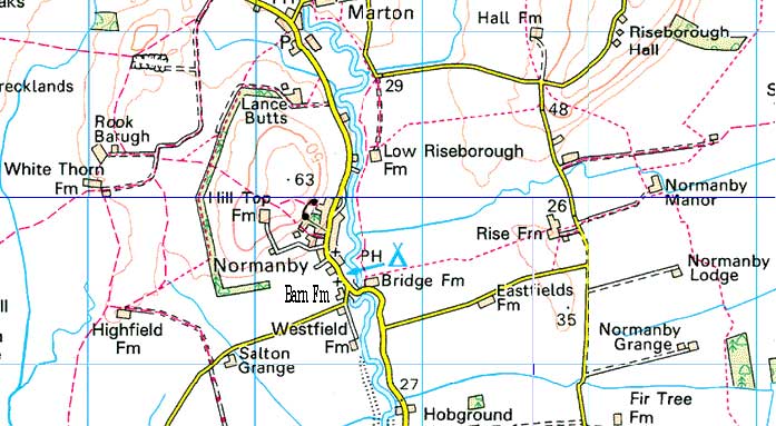
Normanby lies 4 miles
west of Pickering. It covers 1786 acres, with Thornton
Riseborough 593 acres. The population is about 200 - 300, as it has been
for several hundred years. There are few places with such a stable
population. The parish is between the streams of the Dove and the Seven,
near the confluence with the Rye. The land around is the level plain
of the ancient glacial Lake Pickering, except to the west is a small
sheltering hill now known as Normanby Hill (208'
high) consisting of sand, gravel and boulder clay, on old maps it is
labelled as 'Roe Bargh'
(Rookbarugh). Riseborough Hill is 236'. The soil is a clay
loam on a sub-soil of Kimmeridge clay
(Sedimentary deposit of fossiliferous marine clay which is of Jurassic age). The
climate is dry compared with some districts of Britain. Rainfall average is
24".
Names recorded:
| 1086 - Normanebi |
1130 - Normannabi |
| 1147 - Normanby |
1285 - Northmanby |
|
1308 - Normannebi |
The River Seven was the only permanent water supply
in the district for many years right up to the early twentieth century,
leading to the establishment of settlements along its length. There is a
sulphur spring, which contains carbonic acid and
a small portion of neutral salts. This is east of the church and is
recorded as yielding 60 gallons a minute. There is a fossil bearing strata
to the north of the Sun Inn.
- - - - - Map of the many "Bridle Ways and Paths" around the village - - - - -
Top