Explanation
of the
flooding
of
the
River
Derwent.
By Clive
Brewer
I
grew
up with
an
understanding
of
the
River
Derwent
system
in
the
Vale
of Pickering,
given
to
me
by
my
father
and
grandfather,
who both
worked
with
the
rivers.
The
Ordnance
Survey
map
of Malton
and
Pickering,
and
that
of
the
North
Yorkshire
Moors
Eastern
Area,
are
both
helpful
in
understanding
the
siting
and
flowing
of
the
rivers.
I
was
born
in
1939
in
the
village
of Normanby
in
the
centre
of
the
Vale
of
Pickering,
alongside
the
River
Seven.
This
was
eight
years
after
the
‘great
flood’
of
1931.
My
grandfather
on
my
mother’s
side
had
lost
his
harvest
in
the
1931
flood,
and,
at
a
later
date,
his
sheep,
which
were
poisoned
by
the
‘green
slime’
left
on
the
land.
This
almost
put
the
family
into
bankruptcy,
a
fact
of which
my
late
mother
never
ceased
to
remind
me.
My
grandfather
on
my
father’s
side
was
a
land
drainer
when
the
old-style
clay
tiles
were
dug
into
the
ground
by
hand.
In
the
1930s he was
made
foreman
by
the
then
newly-formed
River
Ouse
Catchment
Board.
My
father
then
followed
his
father
in
this
occupation.
He
in
turn
was
promoted
to
foreman
when
his
father
retired.
He
did
this
throughout
the
war
years,
and
afterwards
became
the
general
foreman
of
the
River
Rye
Internal
Drainage
Board
until
about
1949.
These
jobs
were
considered
so important
that,
during
the
war
years,
they
were
classed
as
reserved
occupations.
I
have
learned
much
of
this
matter
from
my
father
and
grandfather,
and
at
such
a
time
as
this
I want
to
share
it
with
others
who
are
equally
concerned
for
the
future.
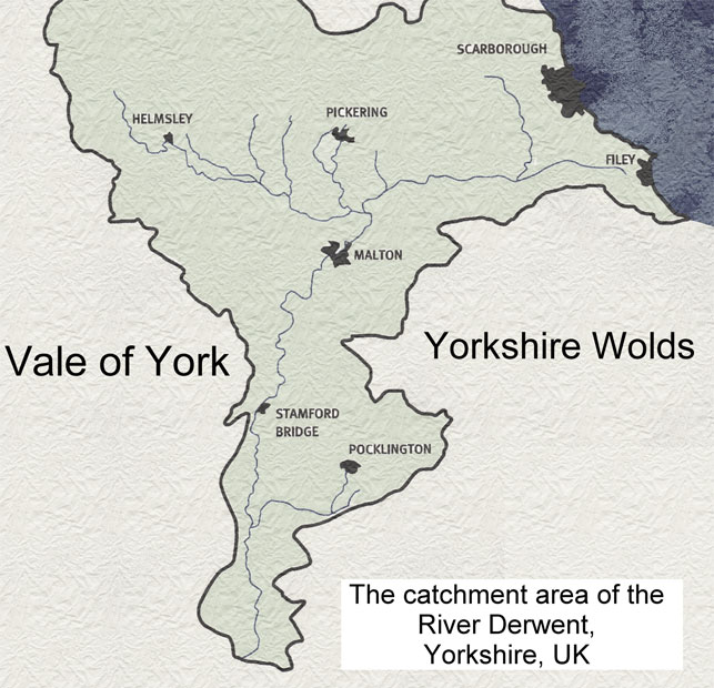
The
Vale
of
Pickering
in
ancient
times
was
a
lake.
In
time
it
drained
itself
through
the
area
which
is
now Old
and
New
Malton,
and
Norton,
then
into
the
Vale
of York
through
Kirkham
Gorge.
The Vale
of
Pickering
remained
swampy,
with
the
main
river
systems
of
the
Rye
and
Derwent
carrying
the
water.
This
explains
why
the villages
are
on
the
edges
of
the
Vale,
apart
from
those
on hilltops,
such
as
Little
Barugh,
Great
Barugh
and
Edstone.
The
drainage
of
the
area
was
poor until
the
major
drainage
scheme
of
the
1930s onwards
was
carried
out by
the
River
Ouse
Catchment
Board.
The
work
involved
deepening
the
channel
and
moving
the
river
banks,
which
were
previously
adjacent
to
the
river,
so
that
they
became
further
away.
This
created
a
flood
plain
above
the
towns of
Malton
and
Norton
for
the
river
in
times
of
excess
water.
The operation
began
around
Kirkham
Weir
below
Malton.
It
progressed
up
the
River
Derwent
to
the
area
of Yedingham,
and
up
the
River
Rye
(which
rises
in
Bilsdale),
and
its
main
tributaries,
being
Pickering
Beck,
the
Seven
(which
rises
in
Rosedale),
the
Dove
which
rises
in
Farndale,
and
the
Holbeck
which
rises
in
the
area
of Ampleforth/Coxwold.
This
work
was
carried
out
on
the
lowest
parts
of
the
Vale
which
were
subject
to
flooding,
in
order
to
prevent
the
flooding
of
upstream
villages
and
homesteads
which
had
occurred
in
the
past;
and
to
ensure
that
the
massive
amount
of water
from
all
these
rivers
was
able
to
flow
through
Malton
and
Norton
without
causing
flood
damage.
Most
importantly,
it
enabled
the
rivers
to
empty
in
a
natural
sequence.
The
river
Seven
normally
reaches
its
peak
flow,
then
recedes,
approximately
six
hours
after
rainfall
in
the
area
ceases.
This
is
followed
by
peaking
in
the
Rye
(between
half
a day
and
two
days
later,
depending
on
rainfall),
then
peaking
in
the
Derwent
(which
occurs
at
Malton
approximately
three
days
after
the
peaking
in
the
Seven).
Should
these
main
river
channels
be
allowed
to
become
wholly
or partly
blocked
by vegetation
or silt,
then
this
natural
flow
sequence
cannot
take
place.
This
results
in
a build-up
of water
which
prevents
the
next
river
in sequence
from
emptying
naturally,
and
creates
a
progressively
worsening
situation
along
the
river
system.
When
extra
water
from
high
rainfall
and/or
thawing
snow on
the
high
moors,
mainly
at
the head
of
the
River
Rye,
reaches
this
build-up
of water,
a flood
is
the
natural
result.
Sir
George
Cayley
(1773-1857),
engineer
and
local
land
owner,
had
the
foresight
to build
a
canal
to
drain
the
eastern
watershed
of
the
Derwent
from
Hackness
to
the
sea via
Scalby
Beck,
thus
preventing
flooding
to
the
land
below
Forge
Valley
at
West
Ayton.
Very
little
of
this
water
now
flows
though
Malton
and
Norton,
as
can
be seen
by
the
size
of
the
Rye
at
Howe
Bridge
and
the
Derwent
at
Yedingham.
The
meeting
of
these
rivers,
approximately
three-quarters
of a
mile
south-east
of Howe
Bridge,
cannot
be seen
in
times
of
flood,
due
to
the
massive
amount
of water.
But
it
can
be seen
clearly
when
not
in
flood,
although
the
difference
is
less
obvious
since
recent work
has
widened
the
Derwent
at
this
point.
The
Derwent
is
the
only
outlet
for
the water
from
all
these
river
systems.
This
water
will
continue
to
flow
downhill
whenever
it
rains
or
when
snow
thaws
excessively
–
this
is
the
basic
principle
of
the
drainage
system.
The
drainage
system
worked
efficiently
until
recently,
when
vegetation
and
silt
have been
allowed
to
block
the
channels.
In
my
opinion,
the
floods
will
continue
to
occur progressively
more
often,
and
in
times
of
less
rainfall,
unless
the
original
drainage
plan
is
re-adopted
by
all
the
relevant
authorities.
We
should
also
take
heed
that
the
flood
of 1931
happened
during
harvest
time.
Blocking
the
river
system
above
Howe
Bridge
will
only
result
in
the
flooding
of
the upstream
villages
of Brawby,
Normanby,
Marton
and
Salton,
as
used
to
occur
in
the 1930s.
It
will
not prevent
the
flooding
of
Malton
and
Norton,
as
water
will
continue
to
arrive
above
this
point,
eventually
breaking
through
with
greater
force.
This
could
then
cause
structural
damage
downstream
where
the
River
Derwent
is
concentrated
under
the
Malton
by-pass.
It
would
them
emerge
into
Old
Malton
and
the
towns, before
continuing
on
its
natural
journey,
as
it
has
always
done,
down
to
Kirkham
Abbey
(which
did
not
flood
this
time)
and
through
the
gorge.
The
work
which
my
father
and
grandfather
carried
out was
on
emergency
relief
channels,
and
these
should
be
maintained
as
such.
The
engineers
of
those
days
designed
this
work
without
the
aid
of
modern
computer
technology,
using
only
common
sense
and
practical
observation
of
the
water
levels
and
behaviour.
We
should not
neglect
their
wisdom
and
foresight.
Liquid
always
flows
to
the
lowest
point,
or
as Grandfather
said,
‘Watter
allus
runs
doonhill.’
Clive
Brewer
1999 &
2007
This
refers
to the
floods
of
March
1999
Back